|
|
|
 |
|
|
 |
 |
 |
 |
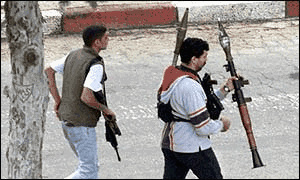
| Key points to remember: 1. The PLO was formed in 1966, before the 1967 war. What part of Palestine do they want to liberate? Not the west bank and Gaza they weren't in Jewish hands at that point. 2. The Arabs did not recognize the 1948 partition seen below. 3. In 1948 Egypt, Syria, Transjordan, Lebanon, Yemen, Saudi Arabia and Iraq all declared war, or invaded Israel. A state of war still exists between all these countries and Israel with the exception of Egypt and Jordan which have signed peace agreements. Additionally Iraq never signed an armistice in 1949 as the others did. Any military action by these powers and Israel (such as Iraqis SCUD attacks) are not new 'acts of war' but continuing acts in an on going war that started in 1948. So Israelis attack on Iraq's nuclear power plant in the 80's was a legitimate military action. 4. Israel armed the Palestinian Authority. 5. Terrorism is using terror against noncombatants in order to get the populace to change a political position out of fear or desire to end violence. (Blow up bus demand release of prisoner, people scared of bombs ask government to release prisoner) When Palestinians blow up tanks or attack checkpoints that's an act of war not terrorism. When Israelis blow up a PA building that's not terrorism. PLO throwing rocks at tanks, not terrorism, PLO throwing rocks at Jews because they are pissed, not terrorism (assault). Throwing rocks at Jews to get the government to pull out of west bank is terrorism. 6. From the Golan heights one can shell Damascus or Galilee. |
|
||||
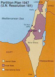 |
OK heres something that always made me curious.. The map the the left
is the UN 1948 partition. Note that there are chunks of purple (Arab)
in the north and in the south (beyond the Gaza strip which is only along
the coast. Why doesn't anyone refer to them as 'occupied territories"?
Why do they not show up on any map? |
![]()
1948 - War of Independence.
Israel secures new territory after being invaded by Arab states. Map
1956 - 1956 War
Israel violates armistice as France and Britain join her to retake the Suez
from Egypt. UN status quo ante-bellum Map
1967 - Six Day War, 1967 War.
As Arab forces mobilize on border Israel launches brilliant preemptive strikes
(how rude) Takes Sinai from Egypt and Golan Heights from Syria. Jordan attacks
and loses West Bank all in 6 days. Map
more
1973 - Yom Kippur War or 1973 War.
Arabs attack on Jewish Holy Day. Did well but Israeli counter attack recovers
lost ground. No change in territory. Israel loses allot of men. Map
more
1982 - Invasion of Lebanon.
Israel invades Lebanon in order to create a buffer zone against PLO rocket attacking
Israel. Following normal operating procedure she takes the capital and forces
the PLO out the the country. Syrian enters Lebanon to 'help'. Israel withdraws
to south and eventually pulls out. Syria still there controlling a puppet state.
![]()
|
|
||
|
The US Military Academy has excellent maps available
on line which show the conflict.
|
BBC has a ceries of simple maps on the conflict
|
|
|
|
|||
|
The quasi-goverment authority that runs a few places
in Israel. Be prepared for some propaganda.
|
Arab League Declaration on the Invasion of Palestine
1948
|
BBC on the conflict
|
BBC Timeline
|
|
|
|||
|
Official Israeli Government Site
|
Israeli National Photo Collection
|
||
|
|
|
|
|
|
IDF Site
|
Israel responds to claims (IDF)
|
Info on Arms ship (IDF)
|
Info on the Kassam II rocket (IDF)
|